
Monitoring Extreme Climate and Hydrometeorological Events (MECHE) - Equipment
Meteorological equipment to be used as well as associated parameters measured are shown in Table 1. This table indicates which parameters are measured at which site. Both sites will be equipped with Micro Rain Radars (MRRs) and Parsivel disdrometers. Additionally, a portable iMet GPS atmospheric sounding system combined with radiosondes and meteorological balloons can be launched from both locations. The sounding data can provide a detailed description of the atmosphere up to 30,000 m in elevation during extreme events.
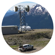
There is an existing meteorological station at Terrace that measures standard meteorological parameters. Additions to this site will include a K63 Hotplate, an 0872F1 Ice detector, and an Apogee net radiometer (SN-500-SS), which measures both incoming and outgoing shortwave and longwave radiation. This will yield critical information on radiative fluxes during extreme storms that affect Terrace.
At Huckleberry Mines, a new meteorological station will be set up using an SR50 snow depth sensor, temperature probes, and a new ClimaVUE50. The ClimaVUE50 is an 'all-in-one' meteorological sensor that will allow for the measurement of many typical meteorological parameters.
The Metek MRR-2, produced in Germany, is a specialized meteorological radar consisting of a compact dish with attached radar. The MRR produces a profile of the lower atmosphere at a height range of 15 m - 6,000 m above the earth's surface. In a vertical column above the MRR, the instrument emits small pulses of electromagnetic waves that bounce off of obstructions in their path. This enables the MRR to detect particle size as well as velocity of falling precipitation in the Doppler spectra (Doppler velocity). The results are a comprehensive distribution of particle sizes. The MRR's ability to capture the evolving height of the melting layer and the formation of frozen particles is of particular interest.
The OTT Parsivel2 disdrometer is a laser-based precipitation sensor that was also developed in Germany. The instrument consists of two separated sensor heads, between which a laser beam is shone. When precipitation passes between the sensor heads, it obstructs the laser beam by a measurable amount and for a detected length of time, which allows the instrument to capture both size and velocity of particles. These measurements are binned into a matrix of 32 different classes based on their size and velocity, providing precise precipitation data at ground level. This instrument therefore diagnoses present weather and discriminates between different types of precipitation such as rain, ice pellets and snow.
The K63 Hotplate precipitation gauge records total precipitation by way of a microcontroller, environmental sensor, and two heated plates located in its sensing head. When frozen or freezing precipitation lands on the sensing head, it is evaporated and measured as a liquid equivalent. The Hotplate allows for measurement of various precipitation events, including frozen or freezing particles and short-lived precipitation events lasting greater than or equal to 1 min.
The Goodrich Icing Detector (0872F1) measures ice accumulation through an axially vibrating tube technology. As ice accumulates on the exposed, vibrating probe assembly, the frequency of vibrations changes. These changes are then communicated to a data logger. The icing detector allows for measurements of ice accumulation as low as 0.13 mm, providing data on icing and melting events and their durations.
For the purposes of this project, meteorological data collection will occur at 1 min intervals. This data will be collected and stored using a combination of Campbell Scientific CR1000 and CR1000X data loggers and two Internet-equipped computers operating a Windows 10 interface. We aim to have live data displayed online for the duration of this project.
All raw data acquired during the course of the project will be made available to partners as soon as possible. Data is planned to be released to the public within a year of the project's end date, following quality assessment and quality control.
Principal Contact:
Dr Stephen Déry (mouseover for e-mail address)
Natural Sciences and Engineering Research Council of Canada / Rio Tinto Industrial Research Chair in Climate Change and Water Security,
Northern Hydrometeorology Group,
University of Northern British Columbia