Introduction
Since the 19th century, various planning concepts
have been put forward as alternatives to the standard practice of the day. These concepts have emerged
as a result of concerns put forth by the public questioning the liveability and
sustainability of our communities.
Current conventionally designed communities seem to lack many
necessities that children, single, married, or widowed people seek to find when
they are looking to integrate into a community.
There is a growing concern that contemporary development
standards are excessive, outdated, contribute to an expensive and land
consumptive pattern of development,
and constrain innovation to community design (Hodge, p. 121). There is a need to critically examine
existing standards, assess their intent, current relevance, and seek to explore
alternative styles that may be more beneficial to the
liveability and uniqueness of a community. The purpose of this paper is to
introduce the site, its limitations, physical inventories, ecological and environmental
considerations, and potential ideas as to how to plan if given carte blanche
rule over the political and economic boundaries we all currently live by. Our report discusses two alternatives to site
development:
Neo-Traditional design and Conventional design.
The Neo-Traditional design incorporates sound environmental
planning ideals that account for the site's features; the Conventional design
essentially overlooks all the existing ecological aspects of the site and
places emphasis on full site development
for maximum residential, commercial,
and industrial use of space. This
project will examine these two approaches to subdivision design, conventional
and Neo-Traditional, and discuss the design concepts of each approach. The two
contrasting subdivision plans, will then be examined and compared to identify
the advantages or disadvantages of each style.
Background
The City of Prince
George is fortunate to lay claim to an
area of land that is not only historically significant but also economically
vital, enjoyed recreationally, bounded by two mighty salmon spawning rivers,
and is within a stones throw of the downtown core. Over time
the land at the confluence of the Fraser and Nechako Rivers has changed its
utility many times;
Aboriginal communities first called this area home
and hence conducted their traditional social and sustenance way of life before
the early settlers arrived. Then as
forestry became
the dominant industry in this early century the river confluence once again
proved its worth to the paddlewheelers and traders
along both rivers bringing wealth and a substantial population explosion into
the region. Trains however most notably altered the face of Prince George. The land at the confluence of both rivers is
large and flat while also being in close proximity to the centre of the town
making it a logical site for a rail yard. Our site plan area will deal directly
with a portion of this land at the river confluence.
This site will consist of all the property located east of River Road from First Avenue to the Cottonwood Island Park parking
lot bounded by the Fraser and Nechako River. The only exception to this is the small
vacant parcel of land to the immediate
east of First Avenue
and north of River Road
at the First Avenue/River Road overpass.
Our goal is to develop two site plans for this area; one will
incorporate conventional planning ideals; the other will embody
Neo-Traditional, ecological, and environmental
design.
Site Analysis and Baseline
Information
Before any plans can be developed it is important that a full
understanding of the site be developed.
This contributes to the overall viability of any design and ensures that
it is unique and well suited to its individual site. The following background report discusses
physical data (topography, climate, ecology, existing structures, zoning) and
cultural qualities of the development
site, looks at some
site development
challenges, and also identifies potential development/non-development
opportunities in this area.
The following background information formed
the basis and outline that shaped and moulded into our
Neo-Traditional design alternative.
Unlike the "cookie-cutter" style of development
that the conventional design resembles, the Neo-Traditional design plan alternative
is site specific and takes the challenges and opportunities that the site has
to offer into the design.
Physical Data - Site and Adjacent Land
Soils and Water
The development
property lies at the confluence of the Fraser and Nechako Rivers. This site's proximity to the riverfront
provides both an excellent opportunity and also presents some
obstacles that are associated with this location.
Prince George
is located on an old glacial lake bottom, and on a series of riverbed terraces
that were formed
as the glaciers retreated. The Fraser River was formed
at this time,
carrying the melt
waters into the main river channel which once flowed North
into the Arctic Ocean (North of
Soda Creek) (Christensen, 1989).
The Fraser
River
trench is noteworthy for extensive floodplains between Prince George and the
Salmon and Willow
Rivers. This ‘Fraser Soil Complex’ is derived from
the fine textured post-glacial deposits of rivers and streams as well as the
undulating topography except where broken by abandoned arms of rivers or
streams (Kelley & Farstad, 1946). Classes of texture in our study area for the
soils range greatly from sandy loam to clay.
Originally this area supported a heavy stand of tall spruce, with many
trees two feet or more in diameter
at the trunk, and some
large cottonwood and birch. Today, most
of the area has been burned over and the land supports a variable but generally
heavy growth of deciduous trees, with scattered groves of spruce that escaped
destruction.
There at one time
was a natural side channel that flowed through the site. This channel was filled in order to provide a
larger land base (Sedgwick, 1999). The
existing channels other than the main river channel,
are littered with large woody debris and silt and generally have extremely
low flow.
Throughout Prince
Georges history ice jams have often
developed along the river confluence.
The Nechako
Rivers
width varies as it enters our local area and hence creates a climate where
pieces of ice wedge themselves against the river banks causing a chain reaction
effect with other chunks of ice further upstream. Eventually the entire channel blocks with ice
and the water below has less area to move; the water rises and then spills its banks
– this is a major design concern for our plans.
There have been recent efforts to restore the existing side
channels that flow through Cottonwood
Park
in order to create and enhance the salmon habitat, which is crucial for
spawning and rearing. Part of this
channel has since been reactivated. However, it does not flow since there is only
one entrance and exit to the channel.
High water levels from the Nechako
and backed up water from the Fraser are the only two ways that water is able to
penetrate the channel. (see Flood Zone Map in Appendix)
The area at the present time
in undeveloped, and therefore there is little impermeable
surfaces that would limit drainage. The
ground provides adequate surface drainage and holds the ability to filter
pollutants out as it penetrates through the permeable
layers of soil, sand, and gravel. In
addition, there are two natural wetland areas on the site that act as natural
filters for polluted ground water. (See Natural Features Map in Appendix) It is recommended
that these natural wetlands be preserved to increase the environmental
integrity of the site.
One major limiting characteristic of the site is soil
contamination. According to a recent
report done by Keystone Consulting out of Calgary, Alberta,
contracted by CN Rail,
the entire area of the CN Rail yards and surrounding drainage
areas along the shorelines of Nechako
and Fraser Rivers are severely
polluted. The main
pollutant being hydrocarbons i.e. diesel, oil, cleaners, solvents from use on
the railway. This limitation poses a challenge to the
site land use capabilities due to these main points:
Unknown amounts of contaminants in site soils,
Continuous adding of pollutants to site soils from
rail yard and fuel bulk plants
High economic cost of site improvement
to overcome
soil contamination liabilities to enable public use
Soil stability is unknown due to past years of soil
deposition from various sources including sawmills, gravel pits, street snow
removal storage sediment,
and flooding deposits.
Having said this however, the location of the site being near
the Nechako and Fraser
Rivers heightens development
and economic potentials as well as provides for quality recreation and wildlife
uses. Given suitable resources this site
could be developed to
offer the city of Prince
George a positive addition to the city's
already existing recreational infrastructure.
To state it again, cost is the biggest limiting factor to development
and/or rehabilitation of this site.
Manners by which to overcome
some cost
obstacles i.e. contaminated site rehabilitation costs, may be in the form of restrictive
covenants, easements,
or special governmental
funding via the Contaminated Sites Act 1997.
Perhaps such actions
would act as incentives for commercial
and residential development
within the site, in addition to restoration of adjacent areas such as along First Avenue.
There are two major rivers within our study area; the Fraser
and Nechako. The Fraser River is a very
large, pacific flowing, muddy river that carries silt year around. The Fraser soil complex was probably built up
by silts and fine sands deposited during the greater freshets. The Nechako
river is a fast flowing clear river that carries very
little silt, even in the freshet stage; Its terraces are gravely with only a
very thin overlay of silt.
|
Flowing Water Feature
|
Length (km)
|
Drainage Area (km2)
|
Mean Discharge (m3/s)
|
|
Fraser River
|
1 370
|
232 300 (800)
|
3 540
|
|
Nechako River (to head of Eutsuk Lake)
|
462
|
47 100
|
-
|
Natural Resources Canada
The National Atlas of Canada
Online
http://www-nais.ccm.emr.ca/defacto/english/rivers.html
The banks of these rivers are a dynamic system. Depositional and erosional
processes are continuously occurring.
Bank stabilization efforts have generally minimized the erosional processes.
In some
areas, west of the site, the banks have been built up and secured with large
rock embankments. Because there is some
threat of continued erosion, a buffer zone between development
and the river bank should occur. This
buffer zone will protect both the riparian ecosystem that lines the banks of
the river as well as the future development.
The development
area has been historically prone to flooding.
Major floods typically occur periodically in the area. The risk of flooding has generally reduced
since the Nechako
has been controlled by the hydroelectric development
by Alcan (Sedgwick, 1999).
Nevertheless, the flood levels are 2-3m above the water table
(Sedgwick, 1999). Because this area is
situated in the flood plain it is crucial that a substantial focus be put on
drainage and ground water levels when the future development
is designed.
A water supply for our developments
could be obtained easily near river level in the second bottom soils, gravel
stratum, more so then in many other soil types found elsewhere in the area. It
may be possible to drill wells that would supply the new development
with water or connect to the city water supply. The depth of the well depends
mainly on the height of the building site above river level. The city water
supply runs along First
Avenue, but at present is not
extended into the site. In addition, Canfor has developed a water system and currently supplies
water to various industries on the opposite bank of the Nechako,
providing an alternative source (Sedgwick, 1999).
Topography
The study area is lower in elevation than most of the city of
Prince George,
including downtown. The contours in the
study area are fairly uniform. However,
there is a general decrease in elevation towards the waterfront. The flatness of the area is due to the
regular flooding of the river. (See Contour Map in Appendix)
Cottonwood
Park,
a forested area of the riparian ecosystem, has some
more variations in its contours than the adjoining site. Currently, the development
site is mainly graveled and unused, giving an unfavorable impression.
The waterfront is natural in the study area and has not been stabilized
to reduce stream channel erosion.
The landform patterns of the study area are defined by the
flow of the river. The
study area in confined by an irregular shape due to the curving of the Nechako
and Fraser Rivers, and the winding of River Road.
Access to the study area is possible by the River Road, which
stretches East-West, connecting Cameron Bridge with First Avenue / Yellowhead
Bridge.
A pedestrian walkway
passes through the study area, coming from Cameron Bridge and
leading to Fort George Park. The access to the area is limited in the north by
the river and in the South by the Canadian National (CN) railway tracks. The study area is visible when entering into
town over the Yellowhead Bridge, and is
one of the first impressions visitors will get of Prince George. The Canfor pulp
mill and adjoining industries dominate the view from the study site to the
Northeast. Both of these facts will pose a special challenge to the project.
Climate
The regional climate patterns are summarized on the climatic
chart (See Appendix). It gives
information to the average temperature, precipitation, humidity, hours of
sunshine, and wind direction and wind speed.
This information was collected outside the bowl area of Prince George and is
therefore not precise for the study area itself. Nevertheless, it gives the general climatic
patterns for the study area.
The local microclimate is mainly defined by the river, the
forest, the cutbanks on the other side of the river,
and its location in the bowl area.
Compared to the main bowl area, the temperatures on the study site will
be lower during summertime
and higher during wintertime
due to the near location to the river and the forest. The forest and the river’s cutbanks will slow the wind, acting as a natural
windbreak. However, the location near
the opening of the bowl area to the east on the Yellowhead
Bridge
allows west winds to blow in relatively strong, which can create snow drift
problems during wintertime. The snowfall in the study area will be
comparative to this of the city of Prince George.
Air quality sound levels are of concern in the
study area. The pulp mill on the
opposite of the river diminishes the air quality immensely
and exerts an unfavorable odour. The sawmills, which
are located near to the study site, pollute the air with wood dust. The railway
and the highway, which cross the river near the study area, as well as the
train switching station, create a high level of sound pollution.
A development
adjoining Cottonwood
Park, will have little effect on the
humidity as any vegetation removal will be compensated by the addition of
landscaping. We also do not predict any
significant change in wind patterns that may result from the proposed development. The project itself will not cause any
radiation or toxic hazards and any negative impacts should remain minimal if it
is designed in an ecologically sound manner.
A positive result of a development
of the study area will be an increase of citizens' attention to the industrial
area near Cottonwood
Park. At the present, Canfor
pulp mill and other industries are very well hidden behind the CN railway
yard. This increase of people’s
attention and visitation of the area may pressure industry to decrease their
output of pollutants. Thus, new development
in the area may actually improve the quality of the environment.
Ecology
Our development
proposal lies on what has been historically a cottonwood riparian habitat. The site also contains large cleared vacant
areas with a graded gravel surface currently used for storage. This section will focus on the cottonwood
riparian habitat.
a.) Dominant plant & animal communities
This site is predominantly characterised by a Cottonwood
riparian ecosystem. The riparian
habitat's dominant species, the pioneering black cottonwoods (Populus balsamifera), are in
their senescent stage and a mass die off has begun. This forest was in a climax state until Alcan placed the dam on the Nechako River and
greatly reduced the flow. The result, a restricted water flows without the volume,
regularity or timing that a cottonwood riparian forest requires for
regeneration (Braatne et al, 1996). No new cottonwood seedling recruitment
has occurred in the area and as such, a cottonwood forest in the area will no
longer be viable once the senescent stand dies off. Rehabilitation (suckering via root
scarification or simply replanting black cottonwood) would not be successful
due to the reduced flow (Ritchie, 1999).
If left to natural succession, this site will eventually shift to a
spruce forest, but will remain low shrub for a considerable time
after the cottonwoods die. Currently,
accompanying the dominant cottonwood is the pioneering willow and alder. Examples of other vegetation on site are
black hawthorn, black twinberry, red-osier dogwood, and highbush
cranberry.
Riparian habitat in North
America makes
up less than one percent of the landscape and is home
to more species of birds than all other forested habitat combined (Braante et al, 1996).
The riparian habitat in our location currently feeds and houses, yellow
warblers, tanagers, redstarts, hummingbirds, woodpeckers, sandpipers,
kingfishers, cedar waxwings, osprey and bald eagles. The woodpeckers create hollows in snags and
dying trees which are used for shelter by martens, squirrels, bats, weasels and
wood ducks. Hollows at the base of
senescent trees are also utilised by foxes as dens. There is evidence of beavers in the site area
as well as black bears. Fish that
utilise the confluence area of the Nechako
and Fraser rivers by our proposed development
are sturgeon, rainbow trout, suckers and squawfish. Also, the area provides important salmon
habitat that must receive particular care and attention. Chinook salmon spawn in near-by areas and
make use of the small streams and pools created by the minor flood episodes
that still do occur in the area.
As noted above, this habitat is in its senescent stage and
due to Alcan's dam, will not regenerate into a
cottonwood forest. The number of snags
will increase in the next few years, creating more nesting possibilities for
bald eagles and osprey, but as the thick cotton wood canopy disappears, much of
the protective cover for many other species will also disappear. Thicker, low lying, dense shrub growth will
provide cover for new species, including pest species such as mice and rats. Considering the latter information, the
cottonwood forest should not be considered as an integral part of any design
without considering intensive and costly ongoing rehabilitation.
This site, as mentioned
above, is home
to a diverse array of species. It is
therefore essential that special care be given to ecological impacts that
future development
may have on the riparian habitat.
Man-Made Structures
a) Networks
River Road acts as the planning site boundary. Therefore, everything east of River Road to the
river, excluding the heavily forested area of Cottonwood Park, has been
considered in the overview inventory.
Wide ditches on either side of River Road.
Ditches have patchy cover: Cottonwoods 5 to 30 yrs old; a variety of
grasses i.e.Tall Fescue, Orchard grass.
Various vacant spaces with
remnants of soil fills (initially for purpose of raising land levels and /or
filling drainage areas).
Crushed gravel holding area.
Tail-end of old river arm.
Power lines along River Road; wooden poles with eight lines.
Paved and graveled
jogging, pedestrian, skiing, and biking trails.
Some cable
fences bordering parking lots and trail ways.
Chicken wire protection around the base of some
large cottonwoods.
Car overpass spanning railway.
Tracks and right-of-way to rail bridge.
1st Ave. and River Rd. intersection.
Pumps to control sewer and storm drain overflow.
Welcome
sign to Prince
George
at base of Yellowhead Bridge.
Yellowhead Bridge.
River Road will remain the main access off the car over pass
from 1st avenue
and the Yellowhead
Bridge. However, further network developments
along River Road
and within the planning site will require substantial investment
into roads and utilities.
b) Existing Buildings
The planning area has two sites with structures. Located at the main parking lot nearest the
river is a small, open log canoe shelter with metal
roofing but no flooring or walls, but does serve as a good rain and sun
shelter.
The other buildings found on this site are located within the
confines of the railway museum yard. A
heritage train station (not yet completed) can be found along with numerous
large museum pieces consisting of train engines, rail cars, plows,
and various other pieces of railway equipment. At the far end of the museum yard stands an
old rusty bee-hive burner.
Zoning
Within our site at the Fraser and Nechako
river’s confluence there are only two zonings as
designated by the City of Prince
George (Refer to Zoning Map in
Appendix). The ‘Klein’property,
see appendix map, has been designated as M-2 (Heavy Industrial) while the
remainder of our study area is parkland, P-1.
The M-2 land is mostly vacant except for some
heavy machinery and fill that has been brought in to presumably raise the land
to the 200 year flood level.
The parkland is the larger land base of the two zones. Cottonwood Island Park makes up
the majority of the land at this site.
Paved and gravel pathways, for cyclists and pedestrians, are located
throughout the area as well as benches, parking lots, and a shelter are the
other physical attributes of this P-1 zone.
Some
modification of the existing zoning will be undertaken so as to allow for
residential and retail developments,
changes necessary for
our final conventional and traditional site plans. The zoning bylaws pertaining to development
regulate the minimum elevation of residential buildings in the area to be above
the flood level. The zoning allows for
non residential buildings to be constructed below this level at their own risk
(Sedgwick, 1999).
Cultural Data, Site and Adjacent
Land
1) Resident and Using Population
According to Halseth’s book, Prince
George A Social Geography of BC’s Northern Capital,
there where no more than 100 residential dwellings within our study area. Within this site the number dropped
dramatically over time
for three main reasons. First, this area
historically was too far away from Foley’s Cache where the majority of the
residential, commercial,
and industrial activities took place at the beginning of the nineteenth
century. Secondly, the area was never
zoned for residential use by the city and thus land uses now occur in the area
such as the rail yards and sawmills that are seen as non-compatible with
residential neighborhoods. Finally, a current lack of residential
development
in the area can be associated with perceptions of noise, crime,
health concerns (pollution), and a lack of housing units. Only one housing unit is placed within the
study area that would need relocation, this is a mobile structure located on
the Klein property.
Over the years the city has reduced the amount of land used
for residential purposes in the Cache area and allowed apartments
and townhouses to be built outside of the city centre. (Halseth, 1998: pg.
84) This has caused a trend of high
vacancies in the bowl area and has caused many homebuilders
and renters to leave the downtown, which ultimately leads to the deconstruction
of the community social framework. The perceptions of developing the study area
are closely tied to the history of adjacent lands such as the downtown. These social stereotypes will be dealt with
differently in both the conventional and Neo-Traditional/ecological development
plans.
The realisation that private developers have chosen to avoid
or ignore housing needs issues in Prince
George shaped the
Neo-Traditional/ecological plans goals to create a working social mosaic that
addresses the unmet
needs of disadvantaged people.
Discrimination by private sector landlords appears to be a
significant concern to renters in Prince
George.
The primary reasons for discrimination or unfair treatment
relate to age (too young), race (Native), and financial circumstances (low income
or on income
assistance).”
(Housing Needs Research Project Steering Committee, 1993: pg.
4)
The conventional plan will centre its efforts towards
creating a class and economic based community.
Segregating classes will ensure the developer and the buyer that
property values will be high and they will be “protected” from negative social
issues. In contrast the
Neo-Traditional/ecological plan will incorporate higher densities, social class
mixes, economic diversity, and community centred values. This plan will also be based upon sound
ecological stewardship principles and sustainable development
initiatives to allow future generations to enjoy this area as well.
2) Behaviour Settings: Nature, Location,
Participants, Rhythm, Stability, Conflicts
Cottonwood
Island Park and the
Heritage Trail attract people for its recreational uses such as boating,
running, walking, picnics and other activities harmonious with the
landscape. These areas are not only
valuable for their aesthetic purposes but for their ecological
characteristics. The
Neo-Traditional/ecological plan will attempt to reduce conflict between man and
nature, ensuring the park, trail, and surrounding natural settings are not only
preserved but also expanded. Integrating
native plants into the settlement,
restricting future growth of the settlement
boundaries, and restoring natural water channels are a few examples of how the
plan will overcome
area conflicts. This plan will minimise
negative aspects of development
by meeting the
needs of both residents and the public.
3) Site values, rights, restraints
To increase sales the conventional plan may utilise a small
portion of Cottonwood
Park,
the property closest to the heritage trail with the view of the rivers to
construct the more expensive single detached housing units. This in turn could restrict access to the
park and decrease the natural aspects of the heritage trail. The conventional plan does not allow for
future development,
because of zoning and bylaw regulations.
Furthermore river channels cannot be restored in the settlement
area due to additional cost and safety concerns.
4) Past and Future
The prehistoric past of the study area is undetermined due to
the nature of past settlements. The Carrier (Lheidli
T’enneh Nation), and other
aboriginal communities in the area used the site in the summer
months as a non-permanent fishing village, and at other times
for camping along the river during travel.
Historically the area’s use has been dominated by the settlement
needs of a colonial society. Before it
was bought by the Grand Trunk Pacific Railway (GTP) this site was used as a
reservation. There are no visible traces
of history at the site except for information displays along the Heritage trail
depicting European settlement
of the area, the presence of the Railway Museum, and the
railway bridge over the Fraser
River. The Neo-Traditional/ecological and the
conventional plan do not seem to disrupt any known archaeological sites, or
historic structures. The Neo-Traditional
aspect of the Neo-Traditional/ecological plan promotes building design that
mimics the historical characteristics of buildings in the area, utilising
environmentally
friendly products and processes. Both
planned communities facilitate the need for the relocation of the Canadian
National switching station, to reduce noise and encourage non-industrial land
uses. Some
zoning in the area is heavy industrial, thus the creation of a residential
neighbourhood could conflict with any future plans for industrial or commercial
endeavours that may support the larger economic community of Prince George. However there are many positive aspects a
residential community could bring to the area, such as a connection of downtown
to the waterfront, increased commercial
activity, tourism, and housing for disadvantaged groups; these all could prove
to facilitate future change in a positive manner.
1.0 Is there a Need to Plan Differently
Continuous population growth in the past
four decades, combined with economic and demographic change and rapidly rising
car ownership has spread Canadian cities and towns across large areas of
previously untouched land. Between 1981
and 1986 alone, over 55,000 hectares of land was converted from rural to urban
use (Arendt, 1996).
Much of the land converted over the years has been consumed
by a standard suburban development pattern
consisting of low-density, detached housing units. This suburban model evolved during the
post-war period when the North American
population was growing rapidly (Arendt,1996).
Conditions today are much different than
they were in the post war period. The
low density pattern of post war suburban development,
one time characterized as a model of achievement
is now classified as urban sprawl. This
has brought upon many problems for society including, high infrastructure
costs, loss of agricultural land, social problems (lack of public input in the
decision making process) and inequalities, segregation, and over-dependence on
the automobile that ultimately leads to a degraded environment. Current developments
also seem to lack any sense of place that its residents can identify themselves
with, leading to communities that are unsure about where they live and who they
really are.
In response to these and other problems
with post war developments, the standard
suburban model has been modified only slightly over time. The recognition and importance of preserving
the environment is seemingly becoming more
important and there is also more awareness and understanding of changing
demographics and housing needs due to social inequalities (D’Amour,
1996). Despite these incremental
changes, current planning practices are still not adequately responding to
today’s social, economic and environmental
challenges. A great deal remains to be
done to address the changes occurring within households, municipalities and
societies at large. This project will
provide an example of this inadequate conventional plan and then pose a viable
alternative that will address some of the
concerns that have resulted from our current development
standards.
2.0 Current Development
Standards
The shape and function of new communities
in North America have
become increasingly controlled by an accumulation
of standards and guidelines. These
standards have evolved from a perceived need to ensure consistent levels of
design, safety, and servicing.
Inadvertently, this practice has resulted in a ‘standardized’ vision of
community form. They cover a wide
spectrum of elements ranging from road widths,
size and location of parks, front and backyard setbacks, and size of housing
units (Davidson, 1996). As such, our
current development framework
has taken away the aspects of community that gave them a sense of place and
identity.
The term most often used to characterize
our current communities is ‘conventional development’. This type of development
usually consists of a large partial of land where all the land is divided into
house lots and streets, with the only open space typically being undeveloped
wetlands, steep slopes, floodplains, storm water management
areas, and a token park (Kunstler, 1998). In these types of development
there is usually no nice places to walk, such as a
green way, riverbank, or lakeshore.
There are no open meadows for wildlife
or playing fields for children of any age.
Without any form of a meeting place
where neighbors can easily engage in a causal conversation, the chances of
gradually becoming better acquainted with your neighbors are very slim. Residents of conventional subdivisions miss a
lot of the social opportunities that should be incorporated into the community
development process.
Although no one ever sat down and derived
this form of subdivision development, they
have resulted due to our current societies greed and
hunger for a higher standard of living.
Conventional developments gained
increasingly popularity with developers due to the inexpensive costs associated
with their creation and the large return that followed through maximizing the
number of house lots in their site plan.
3.0 Neo-Traditional Subdivision Design
New development
does not always have to follow conventional guidelines.
This
alternative approach aims towards enhancing and preserving existing site
qualities: site ecology, heritage, viewscapes,
infrastructures, and linkages to surrounding built and non-built environments. Neo-Traditional ideas
combined with an ecological approach to subdivision design is an
alternative form of development
that seeks to ensure a community is more livable from
an economic, environmental
and societal framework.
Neo-Traditional design is an alternative form of development
that incorporates better social, economic, and environmental
conditions during the community development
process. The Neo-Traditional and
Ecological design principles that were followed to derive this alternative
design plan include:
1)
the town center be no more than a 15 minute walk from
any house
2)
houses should be built closer together or side by side
to the street to foster a tighter feeling of community
3)
streets should be constructed narrower and built in
comprehensive patterns which
encourage
walking instead of driving to destinations
4)
architectural style is based on a specific history
5)
building contracted out to many different architects
and builders to ensure diverse patchwork as opposed to a formulate design
6)
civic, commercial,
cultural, and recreational areas should be located as focal points within each
neighborhood
7) communities should be
complete with housing, shops, parks, and civic facilities
8) housing, jobs, daily needs and activities should be in close
proximity of each other
9) most activities should be located close to transit stops
10) housing should be diverse, enabling citizens from a wide
range of social groups, age groups, and economic classes to live together
11) there should be opportunities for employment
within the neighborhood unit
12) communities should have an ample supply of open space
including parks, and green space
13) public spaces should be designed to encourage attention and
use at all hours
14) each community should have a
well defined edge such as park to ensure that sprawling development
is protected against
15) streets and pathways should be fully-connected, interesting,
and promote non vehicular transportation
16) whenever possible, natural
drainage, terrain, and vegetation should be preserved
17) the community design should help conserve resources and
minimize waste
18) street orientation, placement
of buildings and the use of shading should contribute to the energy efficiency
of the community
19) ecological, environmental,
and cultural aspects of the site should be studied and regarded when designing
future development.
Source: (Arendt, 1996 and Curry, 1999).
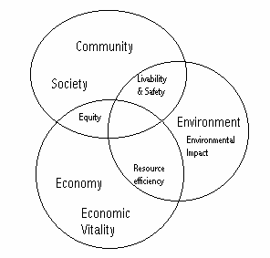
Neo-Traditional design also incorporate
the concept of sustainability, in which communities
are structured to preserve the livability, equity, and resource efficiency of a
community for future generations to enjoy in the same
manner we currently do. Figure 1: Sustainable Community Framework outlines how society, the environment,
and the economy can be integrated with one another to produce a place that is
more beneficial for everyone.
Figure 1: Sustainable Community Framework
Source: (Luttrell,
1997)
The Neo-Traditional Plan
Using
the baseline information that was collected, in addition to the Neo-Traditional
and Ecological Design concepts researched, the following design plan was
created. This plan attempts to balance
the economy, environment,
and community.
The Central Square
The
subdivision is designed around the focal point of the community, the central
square. The central square will foster a
sense of community among the residents, providing a social gathering space. Located within the central square is a
community centre, café/restaurant, Laundromat, post office, corner store and
market. The community is designed in a
way that makes it a comfortable walking distance to the square from any point
in the community. This is extremely
important to reduce vehicular traffic in the neighbourhood.
In addition to the commercial
area, there is also an area for local residents to gather for community
barbecues and picnics. This space is
also centrally located to ensure equally opportunity for its use by all the
residents. The barbecue area is
surrounded by open green space providing opportunity areas for community
baseball, soccer, Frisbee games,
and snowmen
competitions; community events - craft fairs, bake sales, and festivals.
The community gardens are located in the central area,
providing a place for residents of the multifamily complexes to garden. In addition to the benefits that the communal
gardens have for the residents that are enjoying gardening, it also provides an
area for residents to take compostable
materials. This compost can then be used
by the gardeners, thus reducing household waste and increasing the overall
sustainability and self reliance of the community. The gardens also provide an aesthetically
pleasing landscape and view from the central square. The attractive greenhouses create a refuge
that can be enjoyed by everyone.
The central square
is also the place where residents can connect with the existing public
transportation system. It is within easy
walking distance from each residence, make it a viable
alternative to driving.
The children's playground is centrally located so it
assessable for all the neighbourhood children.
In addition, its central location provides a safer environment
for the children. The playground is
within direct view of many of the residences and the is
also in an area of high pedestrian traffic.
This gives both parents and children more freedom as parents will be
able to allow their children to play at the park unsupervised as the community
itself will watch over the children.
4.0
Comparing
the Conventional Subdivision to the Neo-Traditional/ Ecological Style
Compared to the conventional suburban development,
the Neo-Traditional plan has notable strengths: its overall structure and
distribution of land uses and amenities;
the quality of its built environment,
its green space, local economy, and it emphasis on pedestrian and public
transportation, and overall resource efficiency. Compared to our conventional style framework,
the plan attempts to address the issues that citizens are looking for when they
are thinking of entering a community.
Overall the Neo-Traditional community attempts to define a unique
place that gives its citizens a place that they feel comfortable, pleasant and
satisfied to live in.
When comparing the two plans, it becomes
apparent that the Neo-Traditional design is superior on all levels. It is more desirable when considering all of
the aspects associated with a new subdivision; the environment,
community and economics.
7.0 Conclusion
Society
has made the decision that materialistic happiness, greed and wealth are goals
that we as individuals should strive to attain at any cost. As a result, communities built in the
twentieth century have suffered dearly due to the lack of planning that has
gone on during the design process.
Recently, we have begun to see a change in the guard as the public has
begun to voice their opinion on what they feel should be incorporated into the
places they have to live in. Through
this, planners have begun to create new, innovative ways of equipping a
community with all the necessary amenities
that should have been included since day one.
Neo-Traditional design compared to our current conventional style framework
is a much more effective development
that creates an overall better community socially, economically, and environmentally. Indeed, the process of developing a
Neo-Traditional subdivision may take longer due to compared to a conventional
subdivision, however, as exemplified through this project, the end result is
one that citizens of the twentieth century are seeking to find.